|
|
|
|
|
|
|
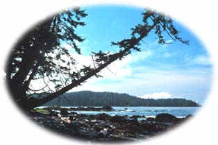
Cape Scott is a rugged, coastal park located on the northwest tip of Vancouver Island. It features 64 km (40 mi) of stormy ocean frontage from Nissen Bight at the northern tip to San Josef Bay at the southern end. In between are 23 km (14 mi) of scenic sandy beaches featuring spectacular views and crashing waves.
Historic trails leading through dense ancient rainforests and around the remains of an early Danish commune, connect San Josef Bay, Nissen, Nels, and Experiment Bights (found further north). The Cape Scott lighthouse, found within the park, still functions today, warning ships of the ragged rocks along the coast of the isolated area. The park is ideal for backpackers seeking a wild and solitary coastal adventure.
|

Cape Scott is a hike-in only wilderness park, although it is also possible to canoe or kayak in the area by entering at San Josef Heritage Park. To reach the park travel north from the city of Nanaimo along Highway 19 to Port Hardy. Alternatively, it is possible to take a BC ferry from Prince Rupert to Port Hardy. Port Hardy can also be reached by air or bus service. At Port Hardy signs mark a gravel logging road which provides access to the park. Sixty-four kilometers (40 mi) down this road is the San Josef campground and the trailhead for Cape Scott.
|
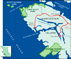
Click on the map to view an enlargement
|

Cape Scott is an interesting park ecologically because of its combination of coastline and rainforest habitats. The coast's major ecological importance lies in the fact that over a million migratory birds travelling the Pacific Flyway use the area as a rest stop. The park also supports prime breeding grounds for thousands of coastal birds.
Cape Scott faces a cluster of islands -the Scott Islands- that have been preserved as the Duke of Edinburgh Ecological Reserve. 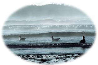 This area, which is off limits to the public and is only accessible to researchers, has the second largest colony of breeding sea birds in Canada. These nesting grounds support over one million birds. The three main species that breed in the area are the rhinoceros auklet, Leach's storm petrels, and fork-tailed storm petrels. This area, which is off limits to the public and is only accessible to researchers, has the second largest colony of breeding sea birds in Canada. These nesting grounds support over one million birds. The three main species that breed in the area are the rhinoceros auklet, Leach's storm petrels, and fork-tailed storm petrels.
The waters surrounding the park are home to seals, sea lions, orcas, gray, and humpback whales. Stellar sea lions are especially well established in the area, their only real enemy being the nomadic killer whales that occasionally kill seal lions.
Away from the crashing waves and gusty winds of the coastline, Cape Scott contains thick lush forests. The trees that make up this temperate rainforest are mainly red and yellow cedar, hemlock, fir, spruce, and lodgepole pine. This dense forest, along with the park's open uplands, is home to black bear, elk, deer, wolves, and cougar.
Mainland Cape Scott also includes Hansen's Lagoon, an important resting area for migrating waterfowl including Canada geese, sandhill cranes, spotted sandpipers, great blue herons, semipalmated plovers, common snipes, and trumpeter swans
|
"The coast's major ecological importance lies in the fact that over a million migratory birds travelling the Pacific Flyway use the area as a rest stop."
|

Hiking
Within Cape Scott there are 40 km (25 mi) of historic trails, of varying lengths and difficulties, ranging from easy day hikes to more vigorous backpacking excursions. From the trailhead it is 2.5 km (2 mi) to San Josef Bay, and 23.6 km (15 mi) to the Cape Scott lighthouse, with several beaches and other interesting points located en route. The park's most popular trail leads to the fine sandy beach of Nels Bight, which stretches along 3.5 km (2.17 mi) of the coast. Many of the trails lead through old settlements, established by early pioneers and later abandoned because of the area's hard conditions.
For more information on hiking in Cape Scott, please visit BC Park's Cape Scott Hiking Information page.
Camping
Camping in Cape Scott is rustic, and without facilities, other than some pit toilets. Some of the most popular wilderness camping areas are Nels Bight, San Josef Bay, Nissen Bight, and Guise Bay. Fresh water is available at these locations, although it should be boiled before drinking. Care should be taken before camping on beaches due to frequent storms and potential flooding from incoming tides. Vehicle campgrounds are located on the road at the park entrance. Eric Lake has 13 designated camp sites available on a first-come, first-served basis.
Safety
It is essential that visitors bring with them a current tide table and be aware of tide changes. Hiking along the coastline is considered dangerous and discouraged unless you are following a designated beach path. Good hiking boots and raingear are necessary. Torrential rain is normal at any time of year including the summer. This can make trails very muddy, and the boardwalk sections can become very slippy when wet. This is a region that receives between 375 and 500 centimeters (148-1102 in) of precipitation annually, often in sudden, violent storms that result in gale force winds. Prepared, experienced backpackers will enjoy the thrill of travelling in this remote and unpredictable environment.
|
"This is a region that receives between 375 and 500 centimeters (148-197 in) of precipitation annually often in sudden, violent storms that result in gale force winds."
|

Cape Scott is the traditional home of two sub-groups of the Kwageulth peoples, the Quatsino in the south and the Nahwitti in the north. Archaeologists have found nine sites that provide evidence of their inhabitancy including burial grounds, shell middens, a pictograph at Experiment Bight, and general activity areas.
Cape Scott was named in 1786 after David Scott, one of the principal financial backers for trading voyages to this region. His name was also given to the lighthouse that has guided ships around the rocky and often stormy cape for centuries. The Cape's lighthouse is one of the last on the coast still tended by a lightkeeper
Danish pioneers attempted to settle the area in 1897, and again in 1910. Both times the incredibly wet, harsh climate forced them to abandon their dreams. Many remnants of their homesteads remain including an Anglican church, homesteads, and even apple trees and rhododendrons from their gardens. Today's hiking paths follow their old wagon roads, which at times are still "paved" by logs.
The area was protected on April 17, 1973 (partly to make up for the dismantling of Hamber Park in the upper Columbia River Valley). Recently the Nahwitti-Shushartie coastal corridor has been added to the park, bringing it to its current size.
|
Return to the Vancouver Island Region
Become Involved!
|
 |
|