|
|
|
|
|
|
|
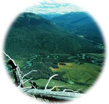
Cariboo Mountains Provincial Park includes a portion of the rugged Cariboo Mountain Range of eastern British Columbia (situated just west of the Rockies). The park's diverse topography ranges from the beautiful alpine meadows beneath the Thompson Ice Field, to tall cedar forests growing in steep valleys, to numerous lakes and wetlands. The Cariboo Mountains feature spectacular scenery, important wildlife populations, and world-class fly-fishing for rainbow trout, lake trout and Dolly Varden as well as perfect opportunities for hiking, photography, or wildlife viewing.
At 113,469 ha (280,000 acres), Cariboo Mountains Park is a key link between Bowron Lakes Park and Wells Gray Provincial Park, which altogether create a 760,000 ha (1.9 million acre) protected area. This means that the majestic cedar forests and wetlands of this area are extensive enough to support large wildlife populations as they move between the three parks. This large range gives wildlife in this region a better chance of survival as unprotected wilderness habitat rapidly disappears elsewhere in this part of BC.
|
|
"The park's diverse topography ranges from the beautiful alpine meadows beneath the Thompson Ice Field, to tall cedar forests growing in steep valleys, to numerous lakes and wetlands."
|

Cariboo Mountains Park is located northeast of Likely and east of Quesnel. Most access into the park is undeveloped, and along active logging roads. While travelling these roads visitors should take extreme caution, and always drive with their headlights on.
Ghost Lake, the only vehicle accessible camping area, is reached by travelling to Barkerville from Quesnel along Highway 26, and turning down the rough gravel Forestry Road #3100 near Barkerville. It is 70 km (43 mi), about 1.5 hours, from the turn off to the park. A 4 km (2.5 mi) access road, marked by signs, leads to the camping area. Alternatively, it is possible to take the #8400 Forestry Road (Cariboo Lake Road) from Likely, until it connects with the 3100 Forestry Road. This route is about 90 km (56 mi) long.
Other access is by trails from the McBride Valley, or by boat or logging road from Quesnel Lake. There are no trails linking Wells Gray or Bowron Lake Parks with Cariboo Mountain Park.
|

Click on the map to view an enlargement
|

The Cariboo Mountain region is an excellent area for hiking, camping, canoeing, lake kayaking, fishing, swimming, wildlife viewing, and even gold panning. Currently the park 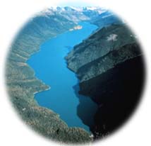 is very undeveloped, with few existing facilities. The area is of most interest to backcountry explorers willing to carry all their own supplies in, and able to be completely self-sufficient. is very undeveloped, with few existing facilities. The area is of most interest to backcountry explorers willing to carry all their own supplies in, and able to be completely self-sufficient.
One beautiful hike is the 14 km (8.7 mi) Cameron Ridge Trail, which climbs along Cameron Ridge to the Cariboo Mountains Lookout. This trail was built by the Cariboo Mountains Wilderness Coalition as part of their efforts to protect the area. It is an easy hike through lovely sub-alpine meadows and surrounded by peaks, that leads to a stunning overlook of the north arm of Quesnel Lake. The trailhead is located about halfway (70 km/43 mi) between Barkerville and the town of Likely.
|

Cariboo Mountains Park supports a complex and important predator prey system composed of many animals, including grizzly bear, caribou, moose, and waterfowl. This region also protects important rainbow trout, lake trout, and Dolly Varden habitat. The rivers and tributaries that drain into Quesnel Lake support one of the province's largest sockeye salmon runs. A key feature of the park is its protection of old growth spruce, red cedar, subalpine fir, and hemlock forests. The protection of these forests is extremely important, as the ancient forests in the interior wetbelt Cariboo Mountain region are being liquidated even faster than BC's coastal rainforests.
|
|
"The rivers and tributaries that drain into Quesnel Lake support one of the province's largest sockeye salmon runs."
|

Protection of Cariboo Mountains Provincial Park was only achieved after many years of citizen advocacy by the Chilcotin Mountain Wilderness Coalition. But its importance has long been known. The area was originally identified as a Special Management Area by the Williams Lake Timber Supply Review in the 1980s, and later recommended for protection by several land-use planning processes including the Protected Areas Strategy, and the Cariboo-Chilcotin Commission on Resources and the Environment (CORE) The park was finally protected in 1995, after being recommended by the Cariboo-Chilcotin Land-Use Plan.
|
|
"At 113,469 hectares, Cariboo Mountains Park plays an important role in connecting Bowron Lakes Park with Wells Gray Provincial Park to create a large 760,000 ha protected area."
|
|
Return to the Cariboo Mountains Region
Become Involved!
|
|
|
|