|
|
 |
|
|
|
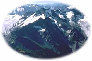 The Purcell Wilderness Conservancy Provincial Park encompasses almost 200,000 ha (500,000 acres) of pristine wilderness. The area has been almost entirely undisturbed by the roading, logging, and mineral exploration that has impacted much of the Kootenay Rockies Region. In fact, the Purcell Wilderness is one of the largest intact ecosystems still remaining in southeastern BC. While the park was created in order to maintain the viability and diversity of this thriving ecosystem, it also happened to include some of the most spectacular scenery in southern BC. The Purcell Wilderness Conservancy Provincial Park encompasses almost 200,000 ha (500,000 acres) of pristine wilderness. The area has been almost entirely undisturbed by the roading, logging, and mineral exploration that has impacted much of the Kootenay Rockies Region. In fact, the Purcell Wilderness is one of the largest intact ecosystems still remaining in southeastern BC. While the park was created in order to maintain the viability and diversity of this thriving ecosystem, it also happened to include some of the most spectacular scenery in southern BC.
The park encompasses part of the rugged Purcell Mountains, the first mountain range west of the Rockies and the dividing line between the East and West Kootenays, as well as several lush valley bottoms. Purcell Wilderness Conservancy Park, combined with adjacent St. Mary's Park, provides not only an excellent place for nature to flourish as it has for millennia, but also a place for humans to revel in this wildness.
|
"...the Purcell Wilderness is one of the largest intact ecosystems still remaining
in southeastern BC."
|

The spectacular Purcell Wilderness Conservancy is located in the unroaded wilderness found between Highway 31 and Highway 93/95 (the two highways come together in this region). To the southwest of the park is the small community of Kaslo, while the town of Invermere is located to the northeast. It is possible to access the Purcells from either of these communities.
From Invermere good gravel roads lead 20 km southwest along Toby Creek, to Whitetail Lake in Dutch Creek. Another road 30km up the Toby Creek accesses the Earl Grey Pass trailhead. It is possible to drive within 5 km of the park boundary, and then enter by way of well established horse and hiking trails, which extend up each major valley. Access to this region from Kootenay Lake is by way of Argenta. St Mary's Lake Road south of Kimberley also provides access to the alpine lakes region.
|
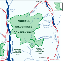
Click on the map to view an enlargement
|
|

The Purcell Wilderness Conservancy Park features five different major ecosystems. On the wetter western side of the Purcells, the low elevation cedar hemlock rainforests found in the valley bottoms give way to ecosystems dominated by montane spruce, then Engleman spruce and subalpine fir, and finally alpine tundra. On the east side of the Purcells, a rainshadow climate supports drier interior Douglas fir forests at lower elevations. 
Grassy meadows scattered throughout the park provide range for outstanding populations of elk and moose. The Purcell Wilderness also provides important habitat for whitetail deer, black and grizzly bears, mountain cariboo, mountain goats, pileated woodpecker, and cutthroat trout. Over 68 species of birds have been identified in the region.
The biggest threat to the wildlife and biodiversity of Purcell Wilderness Conservancy Park is development on adjacent lands. Licenses have been granted to tourist operators to bring visitors in by helicopter for heli-skiing or heli-hiking just outside the park. This could threaten the mountain goat populations in the region, as the Purcells contain important habitat for this species, animals known to be very sensitive to overhead aircraft. Also, a large ski resort proposed in a valley adjacent to the Purcell Wilderness would cut through prime grizzly denning territory, impacting populations within the park. Conflicts like these can be avoided if the tourism zonation system developed by BC Spaces staff is used to match development projects with appropriate regions so that impacts on wildlife are minimized even as tourism is encouraged.
|
"The biggest threat to the wildlife and biodiversity of Purcell Wilderness Conservancy Park is development."
|
|

The Purcell's high mountains, pristine lakes, flowing grasslands, and alpine wildflower meadows draw adventurous backcountry trekkers. Other visitors come for the fishing, hiking, horseback riding, ski-touring, and wildlife viewing opportunities. Mountain climbers come to tackle such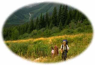 peaks as Mt. Findlay and Hamill, which are both over 3,600 m (11,000 ft) high. peaks as Mt. Findlay and Hamill, which are both over 3,600 m (11,000 ft) high.
The historic Earl Grey Pass Trail traverses the northern portion of the conservancy, a rugged multi-day route that provides stunning views to experienced hikers. This trail was first established by the Shuswap Nation, and was later named after the Canadian Governor-General Earl Grey, after he visited the area in the early 1900s. He so enjoyed the area that in 1912 he had a cabin built for him and his family, which still stands today near Toby Creek. Primitive wilderness campsites are found at various locations throughout the park.
For an extensive description of the recreational opportunities found in the Purcells, as well as some information on the effects of development, please read "Mountain High" by Joel Connelly, a Seattle based reporter.
|
"The area has been almost entirely undisturbed by the roading, logging, and mineral exploration that has damaged much of the Kootenay Rockies Region."
|
|

The Purcell Wilderness was the first large scale wilderness protected by citizen action anywhere in Canada. In the early 1970s, very early in BC's environmental era, a number of environmental organisations came together in the in a campaign to protect the Purcell area. Much of the inspiration for this effort was due to Art Twomey, a renowned photographer who homesteaded in the Purcell Mountains at that time. Their efforts paid off, when, in 1974, 130,000 ha (25,000 acres) of the Purcells were set aside as a Wilderness Conservancy - the first time this classification had been used for a BC protected area.
Twenty years later, after the completion of the East Kootenay Land-Use Plan in 1995, the area was enlarged to more than 200,000 ha (500,000 acres) and reclassified as a Provincial Park. The East Kootenay Environmental Society (now Wildsight) and BC Spaces for Nature took the lead role in accomplishing this. The Conservancy is now the largest protected wilderness in southern BC.
|
Return to the Kootenay Rockies Region
Become Involved!
|
|