|
|
 |
|
|
Stein Valley Nlaka'pamux Heritage Park is significant not only for its old growth forests and spectacular scenery but for its outstanding cultural values as well. For thousands of years it has been of spiritual significance to the aboriginal people in this region; it is essentially a living museum of cultural and natural history.
The Nlaka'pamux people have long lived in this area, recording their history with unique pictographs and petroglyphs found throughout the lower valley. In fact, the Stein contains some of the most significant pictograph sites in Canada.
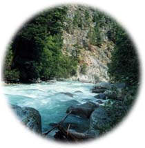
Just over 3 hours drive from Vancouver, the Stein is the largest unlogged watershed in southwestern British Columbia. After a 25 year-long battle to protect this region, this 1060 square kilometer (410 square mile) provincial park is now co-managed by BC Parks and the Nlaka'pamux Nation. The park protects the entire Stein River watershed.
Approximately 60 km (40 mi) long, and completely surrounded by the dramatic Coast and Cascade Mountains, the elevations in the park range from 210 m (688 ft) where the river empties into the Fraser, to 2925 m (9750 ft) at the summit of Skihist Mountain. The watershed encompasses three small glaciers, four major lakes, and about 520 sq km (200 sq mi) of alpine meadows.
To the south of Stein Valley Park lies another of BC's newer protected areas, 23,860 ha (59,000 acre) Mehatl Creek Provincial Park. Created in July of 1999, Mehatl Creek links together with Stein Valley Nlaka'pamux Provincial Park and the Nahatlatch Protected Area to create enough high quality habitat to support species that are dependent on old-growth forests and pristine wilderness.
|
"For thousands of years [the Stein] has been of spiritual significance to the aboriginal people in this region; it is essentially a living museum of cultural and natural history."
|

The Stein Valley is located 290 km (180 mi) northeast of Vancouver, just west of Lytton. To reach the main trailhead into the park from Vancouver take the Trans Canada Highway (Highway 1) to Lytton. At Lytton, cross the Fraser River on the Lytton Ferry, a free reaction ferry (a boat that uses the river's current to propel itself). The ferry operates daily from 5:30 am to 9:50 pm. and holds only two cars.
|
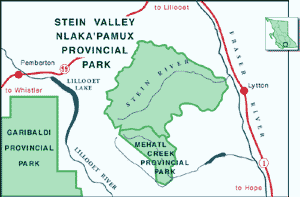
Click on the map to view an enlargement
|
|
Once on the west side of the Fraser River, head north on the West Side Road for about 5 km (3 mi), to its marked junction with the Stein Valley Road. Turn left opposite the house marked "Site 5". Turn left again at the T junction past an abandoned log cabin. Here the road crosses the reserve land of the Nlaka'pamux Nation. It is courteous to ask for permission to continue through their land. After crossing Van Winkle Flats and under a hydro line, the road reaches the parking area.
Other major trails for entering the Park are located at Lizzie Lake, Blowdown Pass and Texas Creek. Lizzie Creek is located off the Lillooet Lake Road and Blowdown Creek is on the Duffey Lake Road.
|

The Stein watershed contains several rich and varied ecosystems including coastal western hemlock forests, ponderosa pine open areas, floodplain cottonwood and birch forests, alpine meadows, glaciers, and river canyons.
This diversity and the Stein's relative lack of disturbance allows this wilderness area to provide a home to at least 50 species of mammals including mountain goat, moose, wolverine, coyote, marmot, and black bear. The Stein park also provides the last refuge for the grizzly bear in the highly developed southwest corner of BC.
Bird species common in the area include pileated woodpeckers, rufous hummingbirds, sharp shinned hawks, barred owls, pigmy owls, white-tailed ptarmigan, and golden eagles, as well as the more common chickadees, nuthatches, and warblers.
|
"The Stein Valley has nourished the First Natives of this region both spiritually and physically for centuries."
|

Hiking
The scenic Stein valley contains 150 km (93 mi) of hiking trails, ranging from easy day hikes, to moderate and difficult 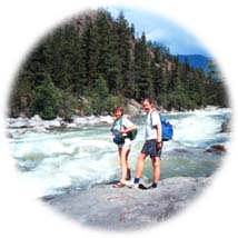 multi-day backpacking trips. Hiking is the only form of access allowed; horses and motorized vehicles are not permitted. multi-day backpacking trips. Hiking is the only form of access allowed; horses and motorized vehicles are not permitted.
A backpacking stove is necessary, as open fires are not permitted. This precautionary measure has been put in place as a result of several forest fires in the Stein, caused by camp fires that got out of control. Hikers must camp only in designated sites while hiking in the lower valley, some of which have pit toilets. The park is usually most accessible from April to October.
The Stein Heritage Trail is one of the most popular hikes in the park. This 58 km (36 mi) trail starts at the sandy bench lands of Van Winkle Flats and extends all the way to Stein Lake, taking about a week. A highpoint of the trail is pictographs found just past Earls' Creek. Pictographs often represent ancient spirit quests and visions of historical events. Please respect the rock-paintings and do not touch them as even lightly touching them can cause irreparable damage. 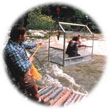
For visitors who have only a weekend to spend in the valley there are two other shorter hiking routes, Lizzie Creek and Blowdown Creek.
Fishing
The Stein River and Stein Lake contain Dolly Varden, char, Rocky Mountain whitefish, and rainbow trout, as well as steelhead trout, coho, chinook, and pink salmon. To ensure there are no problems fish must be immediately cleaned, and their remains returned to the fast moving water. A valid BC fishing license is needed.
|
"Pictographs often represent ancient spirit quests and visions of historical events."
|

The Stein Valley has nourished the First Nations of this region both spiritually and physically for centuries. The rich Stein Valley has provided the Nlaka'pamux with an abundance of fresh green shoots, roots, berries, tubers, medicine, meat, and fish. Evidence of the Nlaka'pamux's inhabitancy is found throughout the valley. Where the Indians once wintered in gigantic pithouses at the confluence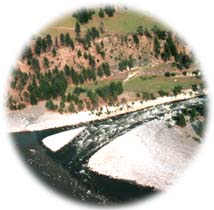 of the Fraser shallow depressions of their winter storehouses can still be found. Numerous culturally modified trees, cedar trees with large, rectangular strips of bark missing, can be found near Teaspoon Creek. This small grove of cedars provided an important source of fibre for cord, clothing, roofing, basketry, and insulating materials. of the Fraser shallow depressions of their winter storehouses can still be found. Numerous culturally modified trees, cedar trees with large, rectangular strips of bark missing, can be found near Teaspoon Creek. This small grove of cedars provided an important source of fibre for cord, clothing, roofing, basketry, and insulating materials.
Approximately 14 pictographs have been found on high ledges, caves, and natural grottos in the valley. These sacred representations of mystical events sometimes include images of guardian spirits who revealed themselves to native youths during solitary coming-of-age rituals. The valley is also said to have numerous traditional power spots.
In the early 1970s Stein Valley was recognized as the last intact watershed within 160 km (100 mi) of Vancouver. On the heels of the successful Nitinat Triangle campaign, conservationists in the Sierra Club organized to try to protect the Stein. Over the ensuing years citizen effort increased but the goal of protection was elusive.
In the 1980s citizen activism included holding rock concerts in the Stein, eventually becoming the famous Stein Valley Festival. Finally in the mid 1990s, the Stein received protection as part of the Lower Mainland Land-Use Planning process. On November 23 in 1995, the Stein Valley Nlaka'pamux Heritage Park was formally made into a park. Sacred to the Lytton First Nation for aeons, this park can now continue to provide a very special, spiritual experience all time.
|
|
Return to the Cascade Region
Become Involved!
|
|