|
|
 |
|
|
|
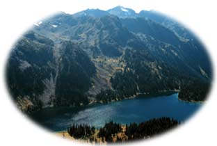
Majestic is a word frequently used to describe Garibaldi Park. A landscape created by volcanic activity thousands of years ago, this magnificent
165,000 ha (408,000 acre) wilderness area encompasses spectacular glaciers, jewel-like alpine lakes, rushing rivers, and dense coastal forests.
Located between the resort town of Whistler and Vancouver, BC's largest city, Garibaldi is a favorite destination for urbanites who come to explore its beautiful mountain terrain. In fact, Garibaldi is British Columbia's most popular wilderness park, attracting 80,000 visitors each year. In the summer Garibaldi is a backpacker's delight, with over 97 km (60 mi) of hiking trails ranging from short day hikes to more strenuous multi-day hikes. In the winter, cross country skiing is a popular activity on the park's 23 km (14 mi) of ski trails.
On its southern border Garibaldi connects with Golden Ears Park and Pinecone Burke Park, to create the largest protected wilderness complex within easy reach of Vancouver. This park complex provides an oasis for wildlife in a region where most of the original forests have been overtaken by development.
|
"...this magnificent 165,000 ha (408,000 acre) wilderness area encompasses spectacular glaciers, jewel-like alpine lakes, rushing rivers, and dense coastal forests."
|

Garibaldi Provincial Park is a 1.5 hour, 97 km (60 mi) drive north of Vancouver, on Highway 99. Many people take the opportunity to drive up to Garibaldi just for the awe inspiring views provided by Highway 99, the Sea to Ski Highway. Several access roads off the highway between Squamish and Pemberton lead to various park entrances. Access to the eastern part of the park is only available by forestry roads from the Lillooet River and Harrison Lake.
|
|
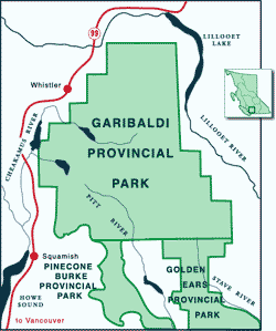
Click on the map to view an enlargement
|

The forests of Garibaldi consist mainly of western hemlock, western red cedar, and Douglas fir. At higher elevations yellow cedar, alpine fir, mountain hemlock, and white bark pine are common. In spring and summer wildflowers including Indian paintbrush, arnica, lupine, and snow lily abound in the alpine meadows.
Garibaldi is home to mountain goats, deer, grizzly bears and black bears, but these are not easily seen. More likely to be seen are squirrels, chipmunks, marmots, and Canada blue jays. Many people come to nearby Brackendale to view up to 3,000 bald eagles feast on salmon in the Squamish River. This river is home to major pink, chinook, coho, and chum salmon runs that attracts one of the largest gathering of bald eagles in the world. The Squamish estuary also supports over 200 other species of birds including endangered trumpeter swans.
|
"[Garibaldi] provides an oasis for wildlife in a region where most of the original forests have been overtaken by development."
|

Garibaldi's five main recreational areas, Diamond Head, Black Tusk, Cheakamus Lake, Singing Pass and Wedgemount Lake, are all located in the western portion of the park. 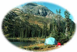
Facilities include over 90 km (56 mi) of hiking trails, 196 wilderness walk-in campsites at 5 separate locations, 23 km (14 mi) ski trails, 4 overnight alpine shelters, 6 day use shelters, drinking water, pit toilets, and visitor programs. Fires are not permitted in the park, so visitors must use carry-in gas campstoves.
This park is a great place for weekends or longer vacations, as there are plenty of trails to explore, good fishing in alpine lakes, as well as mountaineering, ski touring, and photography opportunities.
|
Diamond Head
The Diamond Head area includes Mount Garibaldi, the Opal Cone, Garibaldi Neve and Mamquam Lake. These spectacular sites can be reached by numerous hiking, mountain biking and cross country skiing trails. Diamond Head is popular for its alpine areas, carpeted with pink and white heather and wild flowers in the summertime, and its numerous scenic hikes. Late July to early September are the most popular times for visitors.
Diamond Head is also very popular in the winter with nordic skiers, as it is only a 1.5 hour drive from Vancouver to reach the superb scenery and good snow conditions of the area.
TrailsGaribaldi Provincial Park has a wide variety of trails of different lengths and difficulties, providing recreation opportunities for all visitors. For descriptions of a few of the park's more popular trails, click here.
|
"Many people come to nearby Brackendale to watch up to 3,000 bald eagles feast in the Squamish River."
|

Garibaldi Park was named after its 2678 m (8787 ft) Mount Garibaldi. This mountain was named after Giuseppe Garibaldi, the 19th century Italian guerilla, general, and statesman, by a Royal Navy captain who surveyed the area in 1860.
Garibaldi was designated a provincial park on April 29, 1920, only the second park established by the BC government. In these early days BC Parks was not given a budget to manage the park, and they proposed that the park should be logged in order to provide revenues to manage it. Individuals who loved the park, like botanist Bert Brink, raised a great deal of opposition to this and insisted that Garibaldi should have its own management budget. While funds were not delegated to manage the park until after the Second World War, it did escape being logged. But even though today parks are seen as vital resources, conservationists still have to respond to proposals to log and mine in BC's provincial parks.
|
|
Return to the Cascade Region
Become Involved!
|
|